
Utility Mapping: Precision Below the Surface
You’ve likely heard the industry joke that an excavator bucket is the “best” utility locator. Sure, it finds utilities—with a risk of explosive consequences. At 2M General Engineering, we believe in a smarter, safer approach. Avoid the drama and let us reveal the utilities before the heavy machinery takes the stage.
Make the Invisible, Visible
Navigate with Confidence
Forget the high-stakes game of guessing where to dig. Our utility mapping service equips you with the knowledge needed to break ground confidently. We illuminate the hidden world beneath your feet, providing a clear map of underground utilities, ensuring your project proceeds without unwelcome surprises.
Economic Efficiency in Planning and Design
Unexpected subsurface obstacles can inflate project costs with unforeseen reroutes and redesigns. Our utility mapping minimizes these risks, detailing the underground landscape to streamline civil engineering efforts and safeguard your budget against costly surprises and redesigns.
What Is a Utility Map?
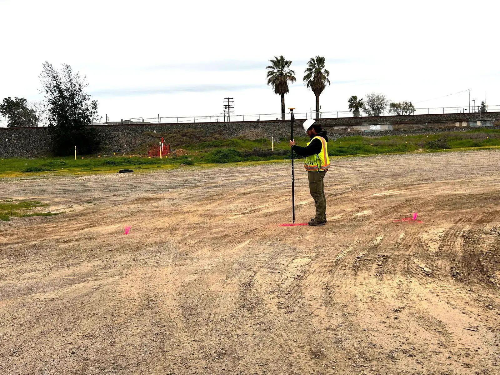
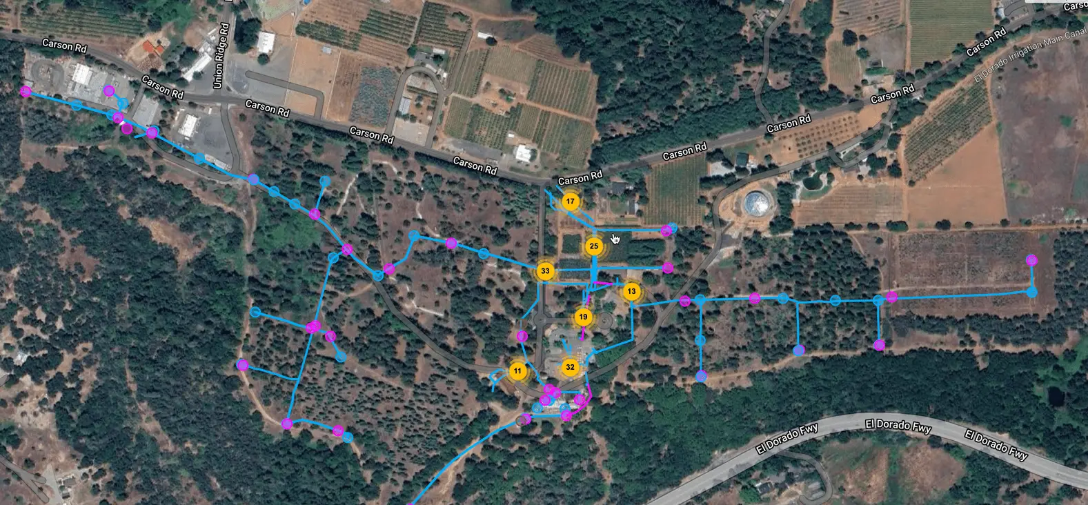
A utility map serves as the ground’s “x-ray,” offering a view of subsurface utilities and structures found within a project area. Our maps are crafted using advanced equipment and software, including GPR and electromagnetic locating tools, backed by the expertise of our experienced drafting team.
We’re Pointman & CivilGrid Certified
Leveraging Pointman, the leading cloud and mobile mapping software, we deliver unparalleled accuracy in utility mapping. This powerful tool complements our GNSS/GPS equipment perfectly, enhancing workflow, ensuring compliance, and providing instant access to critical data.
Leveraging the capabilities of CivilGrid, we enhance our utility mapping and potholing services. CivilGrid stands out as a Construction Intelligence Platform, offering a centralized solution for utility, environmental, and geotechnical site data. Their comprehensive engineering and construction project dataset, accessible in real-time from the cloud, caters specifically to the needs of real estate and infrastructure projects.
Detailed Deliverables
Our utility maps are more than diagrams; they’re your project’s guide to navigating the underground with confidence. Delivered in formats from PDFs and KMLs to CAD and Civil 3D, these maps integrate seamlessly into your workflow, empowering your team with the knowledge to proceed safely and efficiently.

Why Choose Us for Utility Mapping?
- Precision: Our GNSS/GPS equipment, error-correction service and Pointman certification ensure the highest accuracy in utility mapping.
- Comprehensive: From PDFs to CAD formats, our deliverables are tailored to fit your project needs.
- Proactive: By engaging our services in the planning phase, you avoid unforeseen utility conflicts and design cost overruns.
- Expertise: With years of utility mapping experience, we offer depth and detail unmatched in the industry.
Start your next project with the assurance that comes from the most detailed subsurface intelligence available. 2M General Engineering is your partner in unveiling the unseen, ensuring your projects proceed on solid, informed ground.
Request a quote today to learn more about how our utility mapping service can transform your next project.
You’re In Good Company
Trusted by industry leaders, the best of the best keep choosing 2M General Engineering (86% repeat business rate)


Make the Invisible, Visible
Frequently Asked Questions
Our utility mapping service provides comprehensive deliverables tailored to meet the specific needs of your project. You can expect detailed maps in various formats, including PDFs, KMLs, CAD, and Civil 3D files, which integrate seamlessly into your project workflow. These deliverables offer a clear, accurate view of underground utilities, allowing your team to plan and execute projects with confidence and efficiency.
Our utility mapping process begins with a thorough assessment of your project area using advanced Trimble DA2 GNSS/GPS equipment, combined with Ground Penetrating Radar (GPR) and electromagnetic locating tools. This is complemented by our certifications in Pointman and CivilGrid technologies, which enhance our workflow and data accuracy. Our experienced drafting team then processes the collected data to create a detailed utility map, providing a vital resource for your planning and design phases.
Choosing 2M General Engineering for utility mapping means partnering with a team that prioritizes precision, comprehensive service, and proactive planning. Our advanced equipment, certifications in industry-leading software, and years of experience ensure the highest accuracy in utility mapping. By engaging our services early in the planning phase, you can avoid unforeseen utility conflicts and design cost overruns, ensuring your project proceeds on solid and informed ground.
Absolutely. Our utility mapping service is designed to illuminate the subsurface landscape of your project area, identifying potential obstacles before they become problems. By providing a detailed map of underground utilities, we help minimize the risk of encountering unexpected subsurface obstacles, thus safeguarding your project against costly surprises, redesigns, and delays. This proactive approach ensures economic efficiency in planning and design, keeping your project on schedule and within budget.